Louisville, Jefferson County, KY GPS Coordinates: 38.225632, -85.713319
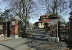
Calvary Cemetery was established in 1921. With over 200 acres, it is the largest of the Archdiocesan Catholic Cemeteries. Calvary Cemetery houses the centralized office for Calvary, Saint Louis, Saint Michael and Saint John cemeteries. Many of our relatives who moved to Louisville during the 1900’s are buried here.
It is located in the Highlands, off Newburg Road.
Campground Church Cemetery
Campground Rd., Nelson County, KY GPS Coordinates: 37.839456, -85.290341
Also known as Beech Fork Methodist Church Cemetery, this cemetery was used by the Stiles and Pile families.
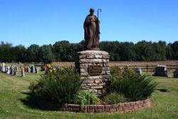
Gethsemani Trappist Cemetery
Gethsemani, Nelson County, KY GPS Coordinates: 37.6641670, -85.5294440
The original location of the cemetery was closer to Monk’s road. Many of the graves were moved to their current location, and some graves have been lost.
It is located adjacent to the Abbey of Gethsemani, This cemetery was used by members of the Peake family.
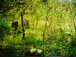
Greenwell Family Cemetery
Icetown Road, Nelson County, KY GPS Coordinates: 37.7193985, -85.5757980
The small fenced cemetery is located near the top of a hill, overlooking a lake. The property is currently owned by Jim Howard. It contains some of the ancestors of Della Greenwell Peake.
It is located less than a mile south of the Nat Rogers / Icetown Rd. intersection.
Highland Memory Gardens
Mount Washington, Bullitt County, KY GPS Coordinates: 38.0625000, -85.5547028
Established in 1958, the cemetery offers traditional in-ground burial, cremation spaces, lawn crypts, mausoleums, and niches.
Howell Family Cemetery
Ginseng, Larue County, KY GPS Coordinates: 37.5037500, -85.5834500
Located just past the end of Giseng Road. Follow the old road up the hollow along the Otter Creek branch, less than 1/4 mile, to the gate at the first gully. Cross the gully and the cemetery it lies about halfway up the hillside. It is a very small cemetery and is heavily overgrown with trees. The graves are randomly spaced in an area about 90 x 90 ft. The Howell mill, store and US Post Office were less than 1/4 mile up the hollow from the cemetery.
The Howell family members buried here are James Howell, the patriarch of the Howell Family at Ginseng, KY, and his descendants. It contains approx. 12 graves.
Mt. Carmel Cemetery
Glendale, Queens County, NY GPS Coordinates: 40.6992060, -73.8877720
A very large Jewish community cemetery founded in 1906. This cemetery was used by members of the Stark family.
Mt. Tabor Baptist Church Cemetery
Buffalo, Larue County, KY GPS Coordinates: 37.4889100, -85.6584200
Located adjacent to Mt. Tabor Baptist Church, both the church and cemetery date back to about 1850. This cemetery was used by members of the Howell and Benningfield families.
Pile Family Cemetery #1
Bloomfield Rd., Washington County, KY GPS Coordinates: 37°44’04.1, -85°15’17.7″
Located on a private drive near Walker Lane, Bloomfield Rd., just over 100 ft. from Highway 55, this small cemetery contains the graves of Benjamin Pile, Sr. and Ruth Ann Vanmeter Roberts Pile.
Pile Family Cemetery #2
Maud, Washington County, KY GPS Coordinates: 37.8180920, -85.2808530
Located on the original Pile farm, this cemetery was used by members of the Pile and Weathers families.
Poplar Flat Cemetery
Bardstown, Nelson County, KY GPS Coordinates: 37.804623, -85.360854
Located in Woodlawn, this cemetery was used by members of the Beam family.
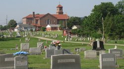
St. Catherine of Alexandria Parish Cemetery
New Haven, Nelson County, KY GPS Coordinates: 37.6611470, -85.5912580
Established in 1844, it is located adjacent to St. Catherine of Alexandria Church. This cemetery was used by members of the Peake, Howard, Greenwell, Rapier, and Thompson families.
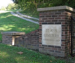
St. Ann Parish Cemetery
Howardstown, Nelson County, KY GPS Coordinates: 37.5780983, -85.5903015
Established in 1863, it is located just up the road from St. Ann Church. This cemetery was used by members of the Howard and Boone families.
St. Thomas Parish Cemetery
870 St. Thomas Lane, Bardstown, Nelson County, KY GPS Coordinates: 37.7691200, -85.4847910
It is located near St. Thomas Church. This cemetery was used by members of the Rapier, Boone, Greenwell and Peake families.
Woodstock Cemetery
Rock City Road, Woodstock, Ulster County, NY GPS Coordinates: 42.0433900, -74.1178900
This cemetery was used by members of the West, Short and Lane families.